|
 Baja California is a unique region, or a set of regions. It posed both distinctive difficulties and special opportunities for its aboriginal inhabitants.
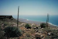
No other peninsula in the world is both as long (about 1,200 km) and as narrow (typically about 100 km). No natural barrier separates Baja California from the North American mainland to the north, but more than 100 km of turbulent water in the Sea of Cortés largely isolated it prehistorically from Sonora and Sinaloa to the east. A partial break in this eastern barrier was formed by the cluster of islands in the middle gulf. Several portions of the  peninsula's variegated coastline face prominent nearby islands, stimulating early peoples to maritime activity. peninsula's variegated coastline face prominent nearby islands, stimulating early peoples to maritime activity.
The region is typically desert, with its rainfall both sparse and erratic, but high temperatures are mitigated by the nearby coasts. Both the northwest and the extreme south receive higher rainfall than the central desert. The aridity of the northeast, lying in the rain shadow of the Sierra Juárez, is offset by the waters of the Colorado River. Climate varies from north to south, between a northern regime of winter storms coming from the north Pacific and tropical summer storms in the south. It also varies from west to east, between a Pacific coast cooled by the south-flowing California current and the warmer waters of the Sea of Cortés. And it varies according to elevation, between hot, dry coastal plains, which are particularly expansive on the west coast, and the cooler, moister heights of the peninsula's granitic and volcanic mountain spine.
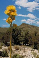 At least nine major plant associations are recognized within the peninsula. Contrasting ecological zones are most closely spaced on east-to-west transects linking the two coasts across the mountains. This juxtaposition of natural variability, together with the frequently erratic water supply at any given location, created strong incentives for aboriginal inhabitants either to be highly mobile between east and west or to organize intercommunity exchange systems, in order to maximize their access to the region's full range of subsistence resources. However, many of the key plant resources, such as oaks, agave, and pitahaya, are present within several of the different plant communities, and important faunal resources such as deer and rabbits also crossed such divisions. Specific littoral and marine resources of fish and shellfish contrasted between the east and west coasts, and perhaps complemented each other in the subsistence of transpeninsular migrants.
 Baja California's prehistoric environments were not unchanging, although few detailed studies of the successive paleoenvironments have been made. Rises in sea level since the late Pleistocene epoch substantially altered the location and configuration of the coastline, probably drowning many early archaeological sites and altering the character of littoral resources. Prolonged periods of drought may have caused severe stress for native peoples, although the region was evidently never depopulated. In the northeast, the gradual growth of the Colorado River delta and the abrupt shifts of the river's course between Lake Cahuilla and Laguna Macuata basins and the head of the gulf continued to constitute a major source of instability as late as the early historic period.
© 2002 Don Laylander
|

)